What is a ceilometer LiDAR? What does a ceilometer measure?
A ceilometer is a device that uses a laser or other light source to measure the height of a cloud ceiling or cloud base. It is primarily used at airports and meteorological stations to assess and report cloud cover, which is crucial for flight safety and operations. Ceilometers can also provide visibility data and measure the vertical visibility in adverse weather conditions, such as fog or heavy rain.

A ceilometer primarily measures the height of the cloud base, which is the lowest altitude of the visible portion of a cloud. Here are the key aspects of what a ceilometer measures:
Cloud Base Height: It provides the altitude at which clouds begin, offering critical data for aviation and meteorological assessments. This measurement is essential for determining flight takeoff and landing conditions, as well as for understanding weather patterns.
Vertical Visibility: In conditions where cloud ceilings are not well-defined, such as during fog or heavy precipitation, a ceilometer can measure the vertical visibility. This is important for assessing how far up visibility is clear from the ground level, which is crucial for aviation safety.
Total Sky Cover: Some advanced ceilometers are equipped to assess the percentage of the sky covered by clouds at various altitudes, contributing to comprehensive weather monitoring and forecasting.
The data from ceilometers are vital for operations at airports, weather stations, and in environmental monitoring to ensure safety and to provide accurate weather predictions.
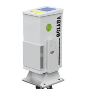
Specifications of YGY150 Ceilometer LiDAR
YGY150
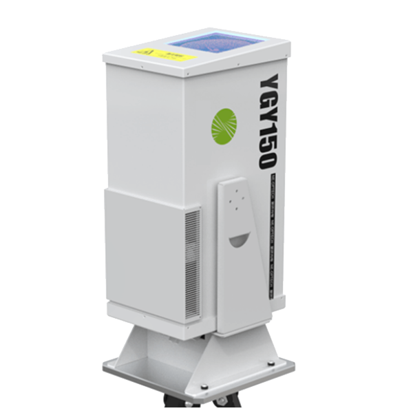
The ceilometer YGY150 is based on the backscattering effect of atmospheric aerosol particles (the main component of clouds) on laser light. It emits detection laser pulses. After the meter backscattering of particles in the clouds, the reflected laser light is reflected by the telescope of the ceilometer. After receiving, the backscattering intensity signals at different times (that is, different heights) are obtained; through inversion calculation, the extinction coefficients of each height layer of the atmosphere are obtained, and then the height and thickness of the clouds are determined.
Specifications
Basic functions: | |
Detection distance (typical value) | more than 15km |
Range resolution | 3m |
Spot diameter | >=10mm |
Temporal resolution | 1s |
Laser wavelength | 532nm |
Pulse energy | 500uJ |
Repetition frequency | 2kHz~7kHz, adjustable |
Power consumption | 200W |
Dimension | 580mm*254mm*335mm |
Weight | <30kg |
Operating temperature range | -20~+50℃ |
Key Features of YGY150 Ceilometer
Portable
Small size, light weight, easy to disassemble and assemble
Long range
Maximum detection radius of 15km
High protection
IP55 or above protection level, suitable for outdoor use, no need to build a station building
High precision
High spatial resolution and temporal resolution, the detection image is more detailed
Cloud-base platform
Customized cloud platform makes data analysis and display more convenient
Multiple scenes
Wide temperature and humidity design, suitable for more monitoring scenarios
Quick warning
Equipment and high-value hotspot warnings
High Integration
Integrated design, integrated ultra-clear video module, and evidence collection while scanning
Applications of YGY150 LiDAR Ceilometer
- Aviation Safety: Ceilometers provide critical data on cloud height and vertical visibility, helping in the navigation and landing of aircraft, especially under poor weather conditions.
- Weather Observation and Forecasting: Meteorologists use ceilometer data to monitor cloud cover and to forecast weather changes.
- Air Quality Monitoring: In environmental applications, ceilometers help in tracking the dispersion of pollutants in the atmosphere, as they can provide data on the boundary layer height, which influences how pollutants are mixed and dispersed.
Ceilometers are integral to various fields, providing essential data for ensuring safety in aviation and aiding meteorological studies and environmental monitoring.
q&a LiDAR Ceilometer
A ceilometer works by using a light source, typically a laser, to measure the height of the cloud base. Here’s a step-by-step explanation of how it operates:
Emission of Light: The ceilometer emits a pulse of light—usually laser light—directly upwards into the sky.
Interaction with Particles: As the light pulse travels upward, it encounters atmospheric particles, including cloud droplets, ice crystals, or dust. These particles scatter some of the light in different directions, including back towards the ground.
Detection of Backscattered Light: The ceilometer has a sensor designed to detect the light that is scattered back towards the instrument. This backscattered light is crucial for determining the presence and height of clouds.
Time Measurement: The ceilometer measures the time it takes for the light to travel to the clouds and back to the instrument. This duration is known as the “time of flight.”
Calculation of Distance: Using the speed of light, the ceilometer calculates the distance to the cloud base by using the formula Distance=Speed of Light×Time of Flight2Distance=2Speed of Light×Time of Flight. The division by two accounts for the round trip of the light pulse (up to the cloud and back down).
Output of Data: The instrument typically displays or transmits the height of the cloud base in meters or feet. In cases where multiple cloud layers are present, advanced ceilometers can provide the heights of several layers.
Ceilometers are integral in aviation for providing pilots and ground personnel with immediate data on cloud heights and visibility, which are essential for safe takeoff, landing, and navigation. They are also used in meteorological stations to monitor and record cloud cover, aiding in weather prediction and analysis.